
Showing posts with label Goosenecks Colorado River utah erosion. Show all posts
Showing posts with label Goosenecks Colorado River utah erosion. Show all posts
Friday, June 1, 2012
A YouTube animation of the annular eclipse...
Now that I'm home from Utah, I spent the day yesterday creating a three-minute YouTube video of the entire sequence of the eclipse on May 20 http://www.youtube.com/divexprt Love that 'Ring of Fire!'

Tuesday, May 29, 2012
Alas, all good things must end...
It's time to go home, anyway. Every hard drive I have is completely full.
Worse, I'm beginning to hallucinate dinosaurs!
 The past two days, the weather has been perfect, so I rushed around to all the best places and shot them again--without clouds!
 If you look carefully, right under the curved swooshes of stone is a blue raft. Guardian angels on duty again!
Ten hours of driving tomorrow, so I'll be offline.It will be nice to get home and sort through 70 gigabytes of pictures and videos! (after some sleep)...
Worse, I'm beginning to hallucinate dinosaurs!


Ten hours of driving tomorrow, so I'll be offline.It will be nice to get home and sort through 70 gigabytes of pictures and videos! (after some sleep)...
My Charley Brown moment...
After a couple of attempts to solve the Yampa Bench Road, today was to be the day. I drove to the eastern end (50 miles) then followed Yampa Bench into the country.
I have to admit, it was lovely country for cattle and horses:
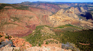
 My favorite guide book had said that there was a side road that led to a spectacular view of the Green River, which runs between the red sandstone cliffs and that white formation in this shot:
 Charley Brown raced down the hill and headed for the football. Ah, but Lucy yanked it away! A chain was rigged across the crucial side road with a big sign that said, "Road Closed."
Score: Yampa Bench Road 53, aging moron still 0...
Still.I couldn't waste that sunny sky! I raced to the Blue Mountain overlook, where signs complain bitterly about California's air pollution drifting here and reducing the visibility.

This was also a day to revisit Harper's Corner. I felt like sir Edmund Hillary!
 Split Rocks was also bathed in warm colors, so I did a panorama to capture it.
 Winding down today before the long drive to Vegas tomorrow. The sky is clear! Woo-woo!
I have to admit, it was lovely country for cattle and horses:


Score: Yampa Bench Road 53, aging moron still 0...
Still.I couldn't waste that sunny sky! I raced to the Blue Mountain overlook, where signs complain bitterly about California's air pollution drifting here and reducing the visibility.

This was also a day to revisit Harper's Corner. I felt like sir Edmund Hillary!


Sunday, May 27, 2012
The best-laid plans...
The day started well, as the skies seemed to be clearing due to tornado-force winds. Even the locals were impresses. Oh, good.
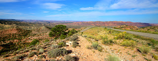
So I drove down here from Flaming gorge and went directly to the cliffs above the Yampa Bench/Echo Park Road: I wanted to drive the lengh of the Yampa Bench, a series of high cliffs above the Green River.
 The wind was howling, but the Sun was breaking between the clouds! What a beautiful-looking day! What could possibly go wrong?
 This was getting good! The sky was clearing! Only 42 more miles to go!
 I was on a roll now! I--wait! What's that?
I skidded to a stop just before Ii slid into a deep gully full of water and mud that looked like quicksand. I got and looked at the gully. Then I looked at the Toyota, which exhibited no boat-like qualities.
Sigh. I turned around, not wanting to be rescued--if anyone were working on the holiday weekend to do rescues.
Score: Yampa Bench Road 1, Ageing moron 0..
Since I was on the road that also goes to beautiful Echo Park (by the way,'park' is the teerm used here for a boat landing), I went there..
With sun still around, I tried to get a better sky for portraying massive Steamboat Rock:
 As I left Echo Park, I passed near Whispering Cave,where there was this artistic rock formation;

Realing that the cloud cover was increasing, I headed for the Iron Springs overlook. I had been there on two days earlier, but the clouds had taken the color out of a grand view::
 The wind is blowing like a hurricane outside my snug bed-and-breakfast room Heaven knows what the morning will bring. I'll deal with it when I see it. I have this mad scheme to go to the far end of the Yampa Bench Road and see how far this way I can come..
So I drove down here from Flaming gorge and went directly to the cliffs above the Yampa Bench/Echo Park Road: I wanted to drive the lengh of the Yampa Bench, a series of high cliffs above the Green River.


I skidded to a stop just before Ii slid into a deep gully full of water and mud that looked like quicksand. I got and looked at the gully. Then I looked at the Toyota, which exhibited no boat-like qualities.
Sigh. I turned around, not wanting to be rescued--if anyone were working on the holiday weekend to do rescues.
Score: Yampa Bench Road 1, Ageing moron 0..
Since I was on the road that also goes to beautiful Echo Park (by the way,'park' is the teerm used here for a boat landing), I went there..
With sun still around, I tried to get a better sky for portraying massive Steamboat Rock:


Realing that the cloud cover was increasing, I headed for the Iron Springs overlook. I had been there on two days earlier, but the clouds had taken the color out of a grand view::

The Gates of Lodore
Got out of Flaming Gorge at 6:45 A.M., which I figured would be plenty of time to beat the late-morning clouds.
Even from the parking area where the river rafters were gathering, the Gates are impressive.
 Note the beautiful sky and ouffy clouds. Lovely. What I hadn't quite counted on was that the place is easy for rafters, butnot kind to ageing morons who want to walk the nearly two miles to get closer. Sigh. The 'trail' is unmarked or nonexistent, and I basically fought my way through the forest to finally reach a good perch for photography.
My guardian angels were already there, sitting on the next rock. "Boss! You're late! We've been trying to hold the !#!$!%!^! clouds back, but they are gaining on us. Oh, and we put some nice rafts on the river to help scale the scene."
 Good girls. By now, the wind was coming up, the clouds were closing, and I still had to fight my way back to the parking lot. Ah, but first, a video!!
Note the rapidly-approaching clouds and their speed? A few minutes later, the whole place was entirely socked in. I didn't see the Sun again until I was back in Flaming Gorge at 3:30 P.M.
I won't dwell on the adventure getting through the woods. I did take a self-portrait with the little blood rivulets on both arms and both legs. Think of them as souvenirs...
The Gates are a one-trick pony, but it is a wonderful trick.
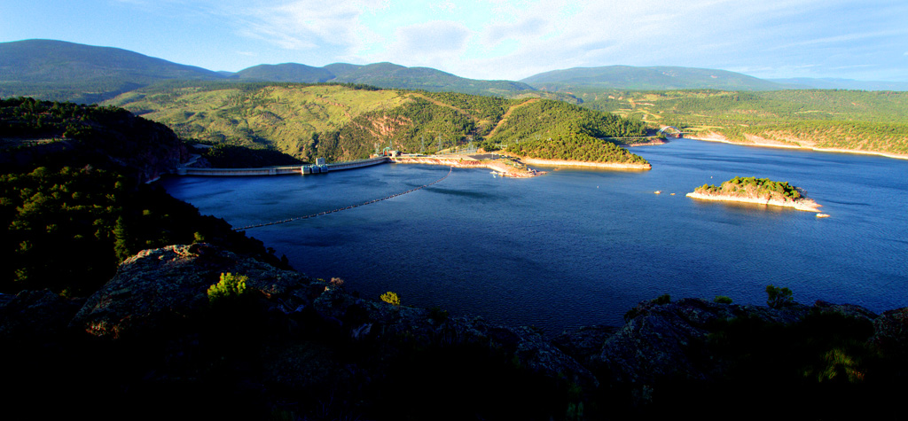
I should mention that I passed a magnificent overlook above the Flaming Gorge. The wind was howling at 40 miles per hour or so, but I managed to hold the camera still enough to get these:

 You can see the back of the dam on the left.
Off today back to Jensen, near the entrance to Dinosaur National Monument.I have three more nights to do the fifty-mile dirt road atop the Yampa Bench and try somehow to get Harper's Corner without the clouds.
Even from the parking area where the river rafters were gathering, the Gates are impressive.

My guardian angels were already there, sitting on the next rock. "Boss! You're late! We've been trying to hold the !#!$!%!^! clouds back, but they are gaining on us. Oh, and we put some nice rafts on the river to help scale the scene."

Note the rapidly-approaching clouds and their speed? A few minutes later, the whole place was entirely socked in. I didn't see the Sun again until I was back in Flaming Gorge at 3:30 P.M.
I won't dwell on the adventure getting through the woods. I did take a self-portrait with the little blood rivulets on both arms and both legs. Think of them as souvenirs...
The Gates are a one-trick pony, but it is a wonderful trick.
I should mention that I passed a magnificent overlook above the Flaming Gorge. The wind was howling at 40 miles per hour or so, but I managed to hold the camera still enough to get these:

Off today back to Jensen, near the entrance to Dinosaur National Monument.I have three more nights to do the fifty-mile dirt road atop the Yampa Bench and try somehow to get Harper's Corner without the clouds.
Friday, May 25, 2012
Another day of wonder...
The weather struggles seem to be generated by the 10,000-foot mountains. Early in the morning it tends to be sunny, the middle of the day is a horror, and the late afternoon clears. This is from yesterday, today only had rain and 40 mph wind.
I spent some time on the Sheep Creek Geologic Loop, a road through a museum of sandstone types. The pictures can't do justice to this place--the formations are huge!
 When I first heard of this drive, I scoffed--but it was huge and impressive:
 When the sun came out strongly, I raced back to Red Canyon to get another view:
 This time, I happened to glance over at the next led just like the one I was on. Uh-oh.
 When I mentioned the danger to a ranger, he shrugged philosophically and said, "We do tell people not to go outside the fence."
Oh, good.
To wrap up the day, a bit of contemplation on the banks of the 90-mile long reservoir.

Tomorrow, a trip to the completely remote Gates of Lodore. can't wait!!!
I spent some time on the Sheep Creek Geologic Loop, a road through a museum of sandstone types. The pictures can't do justice to this place--the formations are huge!


Oh, good.
To wrap up the day, a bit of contemplation on the banks of the 90-mile long reservoir.

Tomorrow, a trip to the completely remote Gates of Lodore. can't wait!!!
Sunday, September 18, 2011
Among the joys of being home...
While I obviously love being on the road shooting pictures, it is nice to get home to a big, powerful computer which handles my panoramas. Some scenes are simply too big for a single shot, no matter how wide the lens. Instead, I shoot several vertical shots which Photoshop then stitches together.
 I also have time when at home to look at the videos I never have the time or energy to watch when traveling. This is the view from Dead Horse Point:
Last year when I went to Moab the mountains had their first snow. This year I went a month earlier, and the view was sublime. This is a horseshoe bend in the road that climbs the mountain group.
 .
.
Then there were the immense vistas one sees from atop the Island in the Sky, the plateau that makes up the northern sector of Canyonlands. This is the view eastward from Grand View: toward the Manti-LaSal mountains:
 And only a couple of miles away on the West side of Grand View is the Green River overlook:

Until the next adventure!...

Last year when I went to Moab the mountains had their first snow. This year I went a month earlier, and the view was sublime. This is a horseshoe bend in the road that climbs the mountain group.

Then there were the immense vistas one sees from atop the Island in the Sky, the plateau that makes up the northern sector of Canyonlands. This is the view eastward from Grand View: toward the Manti-LaSal mountains:


Until the next adventure!...
Wednesday, September 14, 2011
Bidding a fond farewell to Moab
I have done a lot of traveling in Utah, and Moab seems to have the greatest concentration of different subjects to photograph.
And--that is not even to mention all the varied hardbodies one sees each day--river rafters, mountain bikers, rock climbers, hikers. Mix those with all the white-haired park visitors and it is a rich brew.
Alas, it's time to hit the road. Yesterday ended it with a another triumph of sunshine. First I went up in the mountains to take a last look out over Canyonlands:
 A quick stop at Park Avenue in Arches was next, to see the tiny people in the vast scene:
 Then a quick run up the road to visit Sandstone Arch, framing more tiny people:
 On the way back to the motel, I had to take a quick drive out on Route 128, the route of the Colorado as it flows through the town:
 Following the river to the East one revels in the long series deep canyons we also see from atop Grand View when we are in Canyonlands:
 Let me leave you as I head for the highway with a calm moment from yesterday afternoon. A fitting finale to a superb week.
I'm outta here!
And--that is not even to mention all the varied hardbodies one sees each day--river rafters, mountain bikers, rock climbers, hikers. Mix those with all the white-haired park visitors and it is a rich brew.
Alas, it's time to hit the road. Yesterday ended it with a another triumph of sunshine. First I went up in the mountains to take a last look out over Canyonlands:


I'm outta here!
Tuesday, September 13, 2011
What a difference a day makes...
The old song had it just right. I try to schedule enough days on these trips to ride out a period of iffy weather, and it paid off yesterday!
The day began with beautiful skies, so I raced out to the
Red Canyon portion of the Colorado River.There are miles of scenes like these!:
 Then it was on into Canyonlands and the overlook above the Schafer Trail. This road drops an initial 1,400 feet, then goes out to the river canyon and descends another 700 feet.
 As I was taking still photos, a park worker pointed out that a car was coming up the trail, adding motion to the scene.
Out on the promontory overlooking the long trail, the view was heavenly in the sunshine:
 I shot nearly 600 frames this day, so I can only give a slight taste of the wonder of the day. This is a high cliff at Dead Horse State Park overlooking the pans where they dry potash (fertilizer) in the sun, much like harvesting sea salt on Bonaire:
 Today's sky shows promise, but I won't know til I get out there...
The day began with beautiful skies, so I raced out to the
Red Canyon portion of the Colorado River.There are miles of scenes like these!:


Monday, September 12, 2011
Desperately Seeking Sunshine...
Sunday was kind of ugly, what with the sky full of clouds and the roads full of Sunday Grannies who slowed me down as I frantically chased patches of sunshine. The big overlooks were a conspicuous casualty, look for example at the giant mud pie of a shadow as I looked South from Grand View (the tip of Island in the Sky) toward Junction Butte.
 .There was a brief two-hour window where the Sun broke through in early afternoon. Arches had the best of it, since each of the interesting sites could fit into a moving patch of sunshine. I raced to Balanced Rock:
 You don't want to be around when that thing falls. It will go from tourist attraction to projectile in an instant.
Near Balanced Rock is the Garden of Eden, a series of towers whose size was hard to portray until a nice couple with their baby walked right in front of the left-hand tower. Now, that gave a sense of scale to the formations!:
 The Sun held in just long enough for the long walk to Broken Arch. That's it, far out near the end of that line of sandstone towers:
 OK, OK. I take it back. Because it was Sunday, a nice group of tiny people were wandering around the arch to give it scale in the pictures:
 One does get an interesting impression in national parks. Everyone seems to be from somewhere other than America. I listened to a polyglot of European, Japanese and other languages as I photographed various sites. Belgium, France, Germany, Spain and eastern Europe were especially well represented, and I had some pleasant conversations, since everyone has at least some English. My first thought was that we Americans seem to take our own wonders for granted. On the other hand, I'm reminded that I lived in San Francisco for 25 years and went to Muir Woods once. Somehow, a busy career doesn't leave time for touring in one's own country.
Speaking of careers, during the long walk back to the car I got through by cell phone to daughter Kira, who was recovering from a killer week as she tries to wrap up her latest movie. While I loudly scorn the prima donnas who parade on screen, she has given me new respect for the unsung heroes, the technicians who actually make films work.
May I have some sunshine today, please?...


Near Balanced Rock is the Garden of Eden, a series of towers whose size was hard to portray until a nice couple with their baby walked right in front of the left-hand tower. Now, that gave a sense of scale to the formations!:


Speaking of careers, during the long walk back to the car I got through by cell phone to daughter Kira, who was recovering from a killer week as she tries to wrap up her latest movie. While I loudly scorn the prima donnas who parade on screen, she has given me new respect for the unsung heroes, the technicians who actually make films work.
May I have some sunshine today, please?...
Sunday, September 11, 2011
The mornings have been sublime...
...but, as in most of life, the situation deteriorates as the day goes on. I see by the TV weather that the entire southwest seems to have thunderstorms rolling through. Sigh. Looks like more days of 'Cloud Dodge-em.'
Still, the mid-mornings have been clear. Here are the Three Gossips and Courthouse Towers in Arches National Park:
 You get the idea. Look at that clear blue sky. So, I raced up into the Manti-La Sals to get a high view of Cathedrall Valley:
 The Priest and Nuns formations tower above the valley:
 Back in Arches, the skyline is filled with spires of sandstone eroded into fanciful, even whimsical, shapes. These are part of the Devil's Garden, where several major arches are found:
 Soon, however, the clouds came on in battalions and regiments. Every overlook I tried had big black cloud-shadows everywhere.

Moab is right at the foot of the Manti-La Sals where all that rain is falling, so I returned to the motel in a downpour.
Hoping for another clear morning!!
Still, the mid-mornings have been clear. Here are the Three Gossips and Courthouse Towers in Arches National Park:


Moab is right at the foot of the Manti-La Sals where all that rain is falling, so I returned to the motel in a downpour.
Hoping for another clear morning!!
Saturday, September 10, 2011
Into every life some rain must fall...
Henry Wadsworth Longfellow had it right:
"...thy fate is the common fate of all,
Into every life some rain must fall,
Some days must be dark and dreary."
 The Manti-La Sal mountains are tall enough to make their own weather, and it was impressive. The visitors are frolicking at the Schafer Road overlook, but a few minutes later as I was driving along, I thought the raindrops were going to come right theough the windshield.
Earlier, there were a couple of hours of hazy sun, so I raced around to some of the views. This one is near the False Kiva
http://en.wikipedia.org/wiki/False_Kiva

I swore I was going to get to the False Kiva, which involves a long hiks and clambering down a vast cliff. I got this close--the alcove with the Kiva is high up on that wall to the far right.

I knew that if I went across that cliff they would bring me home in a bag, so I retreated. It is a great view on a sunny day, I'm sure:
 All of this is on the Island in the Sky plateau. The Colorado River carves all the scenes on the East side of the plateau:
 On the West side of the plateau, the Green River does its part:
 That was the sunniest moment of the day, which I'd call divine intervention.
Much more to come, if the rains will abate. What a place!!
"...thy fate is the common fate of all,
Into every life some rain must fall,
Some days must be dark and dreary."

Earlier, there were a couple of hours of hazy sun, so I raced around to some of the views. This one is near the False Kiva
http://en.wikipedia.org/wiki/False_Kiva

I swore I was going to get to the False Kiva, which involves a long hiks and clambering down a vast cliff. I got this close--the alcove with the Kiva is high up on that wall to the far right.

I knew that if I went across that cliff they would bring me home in a bag, so I retreated. It is a great view on a sunny day, I'm sure:


Much more to come, if the rains will abate. What a place!!
Subscribe to:
Posts (Atom)