Showing posts with label canyon. Show all posts

Sunday, May 27, 2012

The Gates of Lodore

Got out of Flaming Gorge at 6:45 A.M., which I figured would be plenty of time to beat the late-morning clouds.

Even from the parking area where the river rafters were gathering, the Gates are impressive.

Note the beautiful sky and ouffy clouds. Lovely. What I hadn't quite counted on was that the place is easy for rafters, butnot kind to ageing morons who want to walk the nearly two miles to get closer. Sigh. The 'trail' is unmarked or nonexistent, and I basically fought my way through the forest to finally reach a good  perch for photography.

My guardian angels were already there, sitting on the next rock.  "Boss! You're late! We've been trying to hold the !#!$!%!^! clouds back, but they are gaining on us. Oh, and we put some nice rafts on the river to help scale the scene."


Good girls. By now, the wind was coming up, the clouds were closing, and I still had to fight my way back to the parking lot. Ah, but first, a video!!

Note the rapidly-approaching clouds and their speed? A few minutes later, the whole place was entirely socked in. I didn't see the Sun again until I was back in Flaming Gorge at 3:30 P.M.

I won't dwell on the adventure getting through the woods. I did take a self-portrait with the little blood rivulets on both arms and both legs. Think of them as souvenirs...

The Gates are a one-trick pony, but it is a wonderful trick.

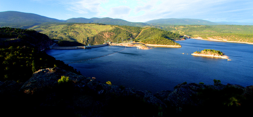
I should mention that I passed a magnificent overlook above the Flaming Gorge. The wind was howling at 40 miles per hour or so, but I managed to hold the camera still enough to get these:

You can see the back of the dam on the left.

Off today back to Jensen, near the entrance to Dinosaur National Monument.I have three more nights to do the fifty-mile dirt road atop the Yampa Bench and try somehow to get Harper's Corner without the clouds.

Friday, June 10, 2011

My car hates me, but...

Yes, I fear another Toyota Rebellion--628 miles today, part of it offroad across the desert. Axle-breaking ruts and the kind of bone-rattling terrain we see in the SUV commercials, but the attractions were worth it.

First, I did manage to get to the Dinosaur Quarry, approximately in the middle of nowhere at all.

Why do all my favorite friends have such impressive teeth? This is an Allosaur: They have found fossil remains of more than forty at this one quarry.
From there I raced to the immense cliffs known as the San Rafael Swell. this is the view from the top of the swell down into Spotted wolf Canyon.


At the end of a very long day, I made a quick trip to the crystal geyser. Unfortunately, it had been erupting for quite a while when I got tthere, so this is only the view as it finishes. As the Terminator said, "I'll be back!"

Off to Spoooooooky Goblin Valley in the morning!

Wednesday, June 23, 2010

The Hole in the Rock...

This is my second post of the day--there was simply so much to be covered in the day!

This location, The Hole in the Rock, was the reason for my 60-mile trip across the desert today.

Thank goodness we had a big 4-wheel drive vehicle. Sure, I could have come here on a boat on Lake Powell--but the way I did it, I feel I much better understand the Mormon achievement.
My Guide, Sean, is very knowledgable guide whose stories helped me understand this achievement. Getting 83 huge wagons down this slot in 1879 strikes me as in the league with Ernest Shackleton's 'Endurance' saga in Antarctica in 1911.

To top it off, that water you see wasn't there in 1879. This water level rose behind the Glen Canyon Dam, built after the Second World War. Those wagons had to go down 600 more feet to the level of the original Colorado River!

Again--how in the world did 225 Mormons, half of them children, get 83 big wagons down that slot?

Monday, June 21, 2010

Nothing could be as dramatic as yesterday. Oh, wait...


Yesterday my Kodachrome Basin adventure ended with a climb up to Angel's Palace overlook, which as you see is crisscrossed with trails--I, of course, had to go to the highest. No remarks.

Then, this morning I stopped at Tropic Ditch, outside of Bryce Canyon, for a spot of morning hoodoos in the early sunlight.

This is along what they call here the Most Beautiful Drive in America. I'm down by the highway looking up toward High Point, the Red formation top left.

This is the view from up on High Point. I drove to my left from here. came into the picture in that row of trees on the right, and drove on down toward Escalante. I'm in a motel there for three nights.

And why come to Escalante? Among other attractions, this is the Lower Calf Creek Falls. It is a five mile killer hike, but the falls are beautiful when you get there!

What a day!


If anyone tells you to drive down Cottonwood Canyon Road to see the Grosvenor Arch, your answer is, "Great! We'll take YOUR car!" My 2008 Toyota Highlander is now fifteen years old.

Oh, all right. it is a pretty drive, even with the ruts and potholes, just because of the flowers.

The Grosvenor Arch is named for Gilbert Grosvenor, long time head of National Geographic, after is was discovered on a 1949 NatGeo expedition that also discovered Kodachrome Basin.


Meanwhile, the mosquitoes in Arizona told the mosquitoes here that I taste like chicken. There was an air Force here waiting for me, and I now have bites on every exposed inch of my glorious body--even my bites from the pond in Sedona have bites!


The bites will heal in a week or so, but the pictures will endure.

In the afternoon, I walked all over Kodachrome Basin State Park, but that will have wait for another post. This picture is of the Grand Parade formations, the signature attraction of the park.

And now, it's time to hit the trail to Escalante and my foray onto Mormon history...