Got out of Flaming Gorge at 6:45 A.M., which I figured would be plenty of time to beat the late-morning clouds.
Even from the parking area where the river rafters were gathering, the Gates are impressive.
Note the beautiful sky and ouffy clouds. Lovely. What I hadn't quite counted on was that the place is easy for rafters, butnot kind to ageing morons who want to walk the nearly two miles to get closer. Sigh. The 'trail' is unmarked or nonexistent, and I basically fought my way through the forest to finally reach a good perch for photography.
My guardian angels were already there, sitting on the next rock. "Boss! You're late! We've been trying to hold the !#!$!%!^! clouds back, but they are gaining on us. Oh, and we put some nice rafts on the river to help scale the scene."
Good girls. By now, the wind was coming up, the clouds were closing, and I still had to fight my way back to the parking lot. Ah, but first, a video!!
Note the rapidly-approaching clouds and their speed? A few minutes later, the whole place was entirely socked in. I didn't see the Sun again until I was back in Flaming Gorge at 3:30 P.M.
I won't dwell on the adventure getting through the woods. I did take a self-portrait with the little blood rivulets on both arms and both legs. Think of them as souvenirs...
The Gates are a one-trick pony, but it is a wonderful trick.
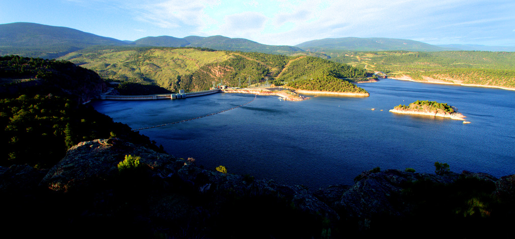
I should mention that I passed a magnificent overlook above the Flaming Gorge. The wind was howling at 40 miles per hour or so, but I managed to hold the camera still enough to get these:
You can see the back of the dam on the left.
Off today back to Jensen, near the entrance to Dinosaur National Monument.I have three more nights to do the fifty-mile dirt road atop the Yampa Bench and try somehow to get Harper's Corner without the clouds.
After forty years of underwater exploration around the world, I'm now exploring the desert parks of the Southwest. All images displayed are copyright protected.
Showing posts with label scenic. Show all posts
Sunday, May 27, 2012
Tuesday, June 22, 2010
Escalante is everything it claims to be...

It is an amazing place, and I have only started. this morning I took a 25-mile drive on a washboard road through the Dixie National forest. Anybody tells you America doesn't have a lot of trees, they're lying. My car is now 20 years old and hates washboard roads,

The target was Hell's backbone, site of this bridge and some colossal views. Worth every rattle and dislodged filling it took to reach it.

Came back down the nost Beautiful Road, which has countless overlooks like this one which is the site of the Escalante river trailhead. No, I'm not going to hike it, I still can't feel my legs from yesterday.

Speaking of yesterday's unspeakable hike, this picture is too small, but the trail runs along the bottom of that red wall across the way. I don't see any bodies on the trail. It creates them.

But, as always. the target is worth it. This is a shot of the falls from the left, and before all the families who were there jumped in. they told me it was icy cold. Everybody knows I don't dive in cold water.
Tomorrow is a big one, a 4-wheel drive to the famed Hole in the Rock Trail, where in 1879 Mormon settlers took 80 wagons down a 1200-foot sheer precipice to get down to Lake Mead. I've read what they did, but still can hardly believe it.
May be a late day. If so, I may not get a blog out for a day or two. I'm off to Capitol Reef National Park Thursday, by way of driving the Burr Trail, which plows about 30 miles of passable road South out of Boulder.
And, of course, on the way to Boulder I drive Hogback, the little road with the thousand-foot dropoffs on both sides.
No rest for those who always want to do too much!...
Thursday, May 27, 2010
Wrapping it up with a 4-mile hike...
The Secret Mountain area is famed for its steep canyons. Boynton and Fay Canyons are two that are accessible--if you like a four-mile hike. I can't feel my legs.
Unfortunately, Sedona has the best government money can buy, so a huge development was built in the mouth of Boynton. The trail goes around it, and you get a good look at a lot of houses in Nuevo Navajo architecture, built by people with plenty of money and guilt who want you to know they are so green they'll live in a giant house inspired by a hogan. Don't say I didn't warn you.
Unfortunately, Sedona has the best government money can buy, so a huge development was built in the mouth of Boynton. The trail goes around it, and you get a good look at a lot of houses in Nuevo Navajo architecture, built by people with plenty of money and guilt who want you to know they are so green they'll live in a giant house inspired by a hogan. Don't say I didn't warn you.Wednesday, May 26, 2010
Oh, and did I forget to mention...?

,,,that today was the day for my Red Baron impression? It was a great day for flying around Sedona, so I did a helicopter tour of the entire perimeter of the huge valley.
I shot thirty clips of video, which I'll edit when I have time at home. Video catches the experience better than stills, but these will do for now.
We flew near some ancient Indian dwellings, several hundred years old, preserved in the shadows of that dark ledge in the center. The Indians chose safe, defensible sites like that one; they could see any threat approaching from their high vantage point.

Then we flew up and down several of the immense canyons on the northwestern side of town. Fay, Boynton and other canyons are favorite venues for the hikers.

Wherever we flew, the scenery was awesome in scale and breathtaking in its rich color.

Oh--and I mustn't forget sunset last evening, when I photographed Cathedral Rocks from a little place where the water catches the reflection. For scale, my guardian angels thoughtfully provided a photographer and his model in the center of the picture--who blessedly stood still in most of my HDR sets. Nice props to show how big the scene really is...
Tuesday, May 25, 2010
All things come to him who waits...

Even good weather! The airport is on top of a mountain between Route 179 (seen here as it passes the Chapel--it's on the right side of the nearest mountain-- and Bell Rock) and Route 89 behind me to the North. This took a hike of a mile or so around the side of the airport mountain with the planes landing over me, but it is a heckuva view and worth every agonized step!
Cathedral Rock (below) has o be the most photographed piece of stone in the valley. You see it from everywhere, and it is nicely photogenic. This is the morning side, seen from Back of Beyond.

Then there is the graceful Bell rock, seen below in the distance from the Chapel. It's the little cone in the distance..

But, of course, when you are standing on its flanks, it doesn't look as small!! There are great views from up here--I'm going to try it again at sunset if the parking lot isn't too full!
Sunday, May 23, 2010
They said it couldn't get worse--but it did...

Ah, lovely Canyon de Chelly! As I write this, the wind is ripping the leaves and bark off the trees outside my hotel window and blowing them to China.
Fortunately, I got to photograph Tsegi Point near the park entrance this morning (the image above) before the winds reached hurricane force.
Then, as things became dire around 10:00 A.M. , I raced over to Antelope House (named for a painting of an antelope on the wall). It is obvious why the Anasazi tucked their homes under the cliffs--this place has brutal heat in Summer, bone-cracking cold in Winter, and these dust typhoons in Spring. In this first shot, you can see the dust beginning to rise into the formerly-blue sky)

A couple of truckloads of tourists were visiting Antelope House, so I included them for scale. Everybody in the hotel looks windblown and bedraggled--probably from riding in those trucks. You can drive your own car up here on the rim roads, but to drive in the canyons and visit the ruins, the Navajos have the only permits.


I'm outta here early tomorrow for Sedona. Think of it as panic-stricken flight...
Saturday, May 22, 2010
A dust storm with 55 mph winds...

It's a good thing I worked so hard yesterday and this morning, because by 2:00 P.M. today the sky was filled with blown sand, the sky turned dust-colored, and the scenic sites began to fade out in a haze of blowing sand. It got worse with each hour, and I had to retreat to the hotel. If one turned into the wind as I did for these, one got a mouth full of sand and eyes that needed a cleaning. Arrrgh. Supposed to be windy tomorrow as well. Sigh.
You can see by the video hy there are only scrubby bushes here--tall trees wouldn't last long up here atop the mesa where the wind howls.
Subscribe to:
Posts (Atom)