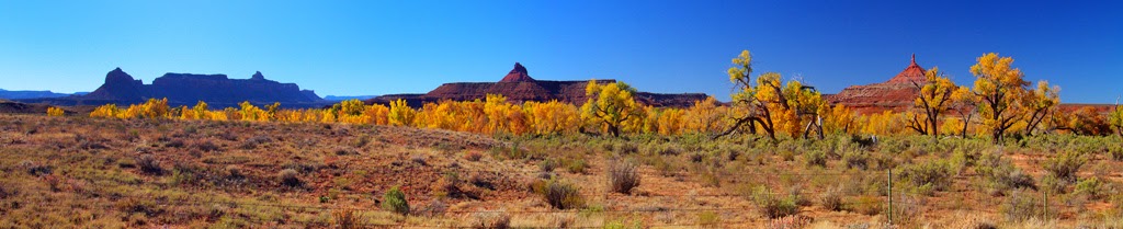
Friday, November 28, 2014

I am honored...

At the just-concluded Diving Equipment and Marketing Show, my business partner in the early days of See & Sea Travel and I were honored with the Historical Diving Society's Diving Pioneer Award.
 
 
No, it isn't crooked, but it is like a mirror and I had to angle the picture to avoid light flares reflecting back at me.
 
The award was presented by HDS-USA founder Leslie Leaney during the annual NOGI Award ceremony.  http://www.auas-nogi.org/nogi.htm attended by a few hundred industry notables.


l                                      
 
None of us can receive such an award without being grateful to the Historical diving Society Board members who chose us and the industry which so rewarded us over the years. I'm sure Dewey, who is no longer with us, would join me in thanking everyone who made this possible.
 
There will be some pictures from the event coming soon, which I'll post then.
 

Saturday, November 1, 2014

Dorothy was right...

...when she said, "There's no place like home."
 
On the other hand, it was a fabulous short trip, the final Indian Summer days before Utah's harsh Winter arrives.. Since Moab is getting rain today (so is Vegas) and snow tomorrow, getting out of Dodge was wise.
 
My motel was excellent, and the owners were very conscientious. The broadband problem apparently affects the entire town (usage growth outstripping infrastructure buildout), I saved the many videos I had shot until I got home.
 
Here's a small sampling. There will be lots more when these make it into galleries on my web site.
 
First, taking off and looking East and West near the Big Bend on Route 128 running eastward out of Moab in Red Canyon:
 
 
Route 128 follows the Colorado River eastward from Moab, and Potash Road follows it westward. The river is a perfect place for the Phantom--only 4,100 feet above sea level and powerfully scenic.
 
 The next video is at the other Big Bend, on the Potash road West of town along the river. On my web site, you may recognize this Gold Bar recreation area as the place where the Crazy Men in their Flying Lawnmowers went up over the river  http://www.divexprt.com/HDRphotography/Moab/2PotashRoad2west/2PotashRoad2west.html 
 
Now I appreciate the view they enjoyed!
 
 
Yesterday, as I fled Moab ahead of forecasted rain and snow, I stopped off at Goblin Valley to visit some old friends. You dimply have to visit the goblins in Goblin Valley n Halloween!:
 
 
Goblin Valley is an ancient sea bed composed of Entrada sandstone eroded into fanciful shapes by millions of years of erosion:
 
 
In the next picture, you can see that I walked all the way across Goblin Valley--my car is in the  parking lot in the distance on the right:


Just to cap off the adventure, I stopped off at St. George on the long drive home to watch a water skier at Quail Creek park:
 
 
The lake is man-made but a pleasant relief from a hundred miles of desert in every direction.
 
 
Now to settle in for the Winter, with the satisfaction of having shot a lot of material in five different states!


Thursday, October 30, 2014

Wrapping up today..

The weather has been incredibly good, but the nights are cold and Dawn is coming later each morning. I had a terrific day yesterday, so I'm finishing up and heading home tomorrow

Still can't send videos, but some stills will suggest how nicely it has gone. This is the scenic Castle Valley from the La Sal mountains:

 
Moab was drowsy in the morning sunlight, seen here from a restaurant with a location, location, location:
 
 
Early in the morning, I went to a man-made lake called Ken's Lake:
 

Nice view for sure, but since it was so calm, I put the Phantom up:

 
Definitely complements the ground view, and you should see the video!
 
Given such good conditions, I headed for the Colorado River, just North of town:
 
 
The river is only at 4,000 feet elevation, so I went twenty miles East and as far West, looking for drone-flying sites. Wish I could show the videos, but I'll be lucky if these come through!
 
 
That is Big Bend on the Potash Road to the West of town.  Now, turning the drone to the West:
 
 
Keep driving down Potash Road, and you come to another of a thousand bends in the river:
 
 
Potash Road runs to the West. If you go just as far to the East in the Red Canyon section, you find another Big Bend. This view looks back toward Moab::
 
 
And if we spin the drone 180 degrees and look East:
 
 
That's it. The wireless has gone down twice while I was doing this, so I'll be home tomorrow and regroup.
 
It was worth the struggle--wait til you see the videos!


:


Wednesday, October 29, 2014

Except for very unreliable Wi-fi, all working out well!...

Had a pleasant day South in the Needles section of Canyonlands.  Nothing sensational, the Fall foliage is fading and stone formations are stone formations.


Far in the distance is the Island in the Sky portion of Canyonlands, where the spectacular cliffs are.


As I said, stone is stone, even when it is the Wooden Shoe Arch:

 
There were still some patches of aspen near stream beds:
 
 
Some kind of water is a prerequisite, it seems: 


I stopped at the Looking Glass Arch:
 
 
I climbed up to the rocks just outside the arch, but remembering my terrible fall at Hope Arch in June (the left arm still hasn't recovered), I stopped there.
 
 
Off to a couple of interesting areas today, then will head home on Friday. Email will be spotty, at best...


Tuesday, October 28, 2014

Welcome to Moab...

We'll see how long this connection lasts. They must have just rebooted the system. It may work for a short while.

I'll quickly toss up a few stills, as I suspect putting up nice videos will bring the system down.

Here is lovely Castle Valley, in Fall colors:


A big bend in the Colorado at Horse Ranch:


And another, called Hittle Corner:

 
And a couple of drone flights over the river. First some 25 miles upriver from Moab:
 
 
Then I turned the Phantom to look upriver from the same spot:
 
 
Several miles West from that corner is a long straightaway:
 
 
I won't push my luck here. the Wi-Fi is creaking and groaning with only a few stills--the videos will have to wait...
 
Hope you get to see this!


Tuesday, October 7, 2014

And for my final trick...

How about driving home via Mount Whitney, the famed location (Alabama Hills) where so many movies were shot, and Death Valley?
 
Here's Mount Whitney from Alabama Hills in a panorama:
 
 
You can see why Alabama Hills was such a favorite for making movies for Hollywood, This kind of scenery only 400 miles away with excellent highway access.
 
Alabama Hills has several small arches, and this astonishing arch called the Mobius  http://en.wikipedia.org/wiki/M%C3%B6bius_strip which by fabulous chance frames Mount Whitney perfectly!
 
 
For another experience, I went up the Mount Whitney switchback road, which you can make out Almost in the center of the picture.
 
 
On the way down. I turned on the GoPro to give a flavor of the seven-minute drive down the mountain. Here's a short sample::
 
 
Then it was off to Las Vegas by crossing Death Valley National Park. The road goes from 5,000 feet down to 100 feet below sea level (!) and then back up to 5,000 feet. It does that twice!
 
Here's the view from 4,000 feet on the West side.
 
 
You can see the road sweeping down toward sea level. Here's how it looks when you're driving it (The entire ride takes 14 minutes, so this is just a small clip):


And so the two weeks ends. All in all, lots of exciting, colorful subjects, which I can work on in coming days.
 
That's all, folks!


Sunday, October 5, 2014

Adieu to the East Slope...

The trip has been very fulfilling, but it's time to sound the retreat after 80 gigabytes of material to work on in coming days.

I went down to Convict Lake  South of Mammoth Lakes this morning. The lake has an interesting history right out of the Old West! Sorry for the shadow on the sign. The short version is, the posse caught up to the escaped convicts here, and the Sheriff was shot (note the misspelling of 'Sheriff' on the sign. You just can't get good help these days).


And what a place for a shootout!

 
From Convict Lake, I went a few miles down the road to Crowley Lake, but the photography from ground level wasn't much. A kind employee told me to drive up McGee Creek road for a better view. His advice was, as that of locals so often is, invaluable!
 
 
That view must be something when those mountains are covered with snow!
 
 
Cars kept driving past me up McGee Creek road, So I became curious and followed them. At the very end of the road, I found that this was a trailhead for hikers to park their cars while they went up into the mountains.
 
Ah, but the drive itself was a rich experience!


Tomorrow, Mount Whitney, the Alabama Hills (where many of the old-time western movies were filmed):


After that, I cross Death Valley on my way to Vegas.
 
Time to go home to Kansas, Toto!