Friday, August 16, 2013

Ghosts of the 1890s silver boom

We don't have cell phone service out here, but Rick ingeniously installed a series of repeaters and got wireless access.

The forest fires are small but frequent, with helicopters flying big bucket of water to douse them. The haze ruins pictures, but we persevere. Today, we drove  up Idaho Peak on the silver ridge, from which the great silver boom extracted thirty-three billion dollars (when that was real money) from the single formation on which we walked.
It would be a fabulous view but for the smoke:

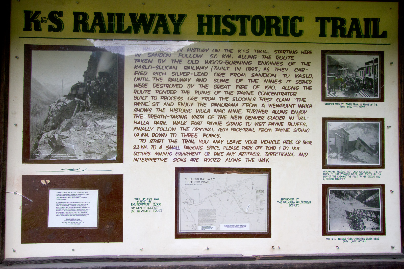
So, since we were in silver country, Rick and Barbara took me to the ghost town which was the center of the boom, Sandon.

In the hills and valley around Sandon, miners dug 1,000 miles of shafts at the rate of three feet per day. These hills were literally honeycombed with shafts:

Here's Sandon's City Hall, from 1900.


This is one of the ore-carrying steam locomotives:
 
 
These are the tailings that mark the entrances of each of the hundreds of shafts:


Here's what a tailings pile looks like when you are standing on it.

Off to Banff in a couple of hours, hoping to outrun the smoke and clouds.

More from Alberta whenever I get back online!

Thursday, August 15, 2013

Silverton with forest fire haze

Enjoyed the drive from Fernie, passing places like Kootenay Lake which is a hundred-mile-long picture extravaganza:

Kootenay is one of five similar lakes running North-South, separated by mountain ranges. I wound my way through the peaks from Kootenay to Slocan, the next lake to the West, where my friends Rick and Barbara Tegeler have a magnificent log cabin home high on a mountainside overlooking the lake. Here's the morning view from the patio:

Sadly, there are some big lightning-caused forest fires around, and the air is smoky. Photographer becomes hysterical.

Yesterday, Rick and Barbara took me out on their boat for a day on the lake. Note the rough seas:


At a pleasant beach, we wandered a short way into the forest to see Nemo Falls:


Rick is an authority on gold and silver mining history, and has visited hundreds of mine sites in California, Nevada and now at an enormous silver rush which occurred here not long after California's gold rush. We took his ATV through the forest high above the lake to the site of a gold mine that ran four miles into the mountain. This is a giant pile of tailings:

Off in the morning to Banff, where the weather forecast is for sunny skies, and with luck the mountains will block all this smoke.

Monday, August 12, 2013

From Waterton Lakes National Park to Fernie, BC

The skies were still leaden as I left the Waterton Lakes area, traveling West on the Crowsnest Pass highway. I stopped at the site of a colossal disaster, when Turtle Mountain collapsed and a giant tide of boulders crushed the town of Frank.


The avalanche of moving boulders flowed hundreds of yards and killed everyone in its path. These views are from the West, then from the East showing the enormous debris field. In the first picture, the field of boulders extends far behind the ones I'm standing on. I'll show it all on my web site later:
 
Then I stopped at the memorial center which overlooks the site from the Western edge. Here you are on a high point to look out over the immense debris field:
 
The skies grew brighter after I left the grave of Frank. I stopped at Elk Creek for a soothing scenic moment:


When I stopped at my motel, the proprietress had a great idea!

 
All the other riders going up were young and hardy, and all had trail bikes with which they roared down a number of twisting trails at breakneck speed.
 
When it came time to go down, I was all alone...
 
 
Tomorrow is a very long day (especially with gasoline at $5.00 per gallon), going from Fernie to Creston to Kaslo to New Denver to Silverton, eh? Supposed to be some grand scenery...
 
There probably won't be much time to process while I'm visiting old friends the next couple of days. I'll pick up again when I get to Banff.
 
I leave you with the little ski resort town of Fernie amid the grandeur of the Canadian Rockies!


Sunday, August 11, 2013

Waterton Lakes National Park, Alberta, Canada.

A forty-minute drive gets you into Canada and to the town of Waterton, on the banks of Waterton Lake, in Waterton Lakes National Park. Got it?

Waterton Lakes Park  in Canada and Glacier in the U.S. are combined into a single international park under the auspices of the U.N.

Waterton is a small vacation town, blessed with a hundred-year-old masterpiece of a hotel, built during the days when the railroad barons opened the west. This is the Prince of Wales hotel:

The hotel is masterfully situated with a commanding view over the lake:

The sky conditions were awful for good crisp photographs, so that is the best I could manage.

True to form in the North, the Akamina road to Cameron Lake was closed for repairs. They have nine months of weather which destroys the roads, then try to fix the damage in three months. Losing game for the visitors, both at the Going to the Sun Road in Glacier NP and here, but easily understood. Given the closure of Akamina, I took a run out to Red Rock Canyon:


It is a small place, which I kept invidiously comparing to our own version in Vegas, but I digress. The rocks were really a bright red from a high concentration of rusting iron particles embedded in the sandstone.

Another local attraction is Cameron Falls (Cameron got around). It is near town, very accessible, and you can climb to the top:


Finally, I was given a warm welcome by the local citizens wherever I went. The youngsters showed great curiosity:


Adorable little fella, eh? The adults take some getting used to: 

You don't want to get into a fight in a bar with that guy!

Please scroll down to the wrap up on Glacier National Park which I just added before this post. With luck, I'll have good Internet broadband along the way and can upload some more videos.

The road goes ever onward...

Glacier National Park wrap up upon departing

Hoping against hope, let's try a couple of short videos:

Iceberg Lake is a nine-mile hike up the mountains, so I chose the helicopter. Age confers wisdom.

Grinnell Glacier melts slowly, keeping the lake full--and cold.

There are few sensations to match soaring over 10,000 feet with this scenery:
There will be some big waterfalls on the Canada portion of this adventure, but for the moment Apikuny Falls, high on its mountain in Many Glacier, will suffice.

There is much more to see when I get home with time to look at it all. 'Til then, it is off to Waterton National Park across the Canadian border!

Saturday, August 10, 2013

Glacier National Park, part three

I did have some real luck before the weather turned ugly. I had booked a helicopter hour, and the weather was glorious. Even the pilot used it to show off. I don't have the bandwidth now for the videos, but they are gorgeous.

this will give you an idea of the scenes:
The astonishing blue of the  lakes comes from the ice grinding particles of metal in the rock so tiny that they remain in suspension.
Here is a hanging waterfall, as the upper lake overflows into the lower.
 
We fly amid these colossal 10,000-foot peaks:
 
I keep losing the lousy Internet connection here in beautiful downtown Pincher Creek. I'll try again in the morning.


Glacier National Park part two

The Going to the Sun Road (GTTS) has dozens of attractions. One near the front gate is perhaps the most iconic picture from the entire park. It is a picture of tiny Wild Goose Island with the tall peaks in the distance.

I intended to be there at dawn for the best light, but the park had the ever-present road repair, and the GTTS didn't open until 7:00 A.m. all week. In any event, here it is shortly after 7:00.
My first day was a Sunday, so I found a construction site in the far distance of that shot above, and took this one looking back at the island:
The real target, though, was Hidden Lake, which is reached by fighting all the other hikers for a parking space at Logan Pass. After 8:30, forget it.
the path leads uphill from the visitors Center at Logan Pass.
A modest little hike up and around Reynolds Mountain, then down the other side. Along the way we were entertained by aggressive mountain goats:
 
It is all worth every step:
I have multiple shots of this entire scene to make a big panorama.
On day two, I did take another of these 'all uphill' hikes to Apikuny Falls:
 
Some day, over an adult beverage, I may tell the story of the bear on that hike. The story has to marinate for awhile...
 
On to part three!